
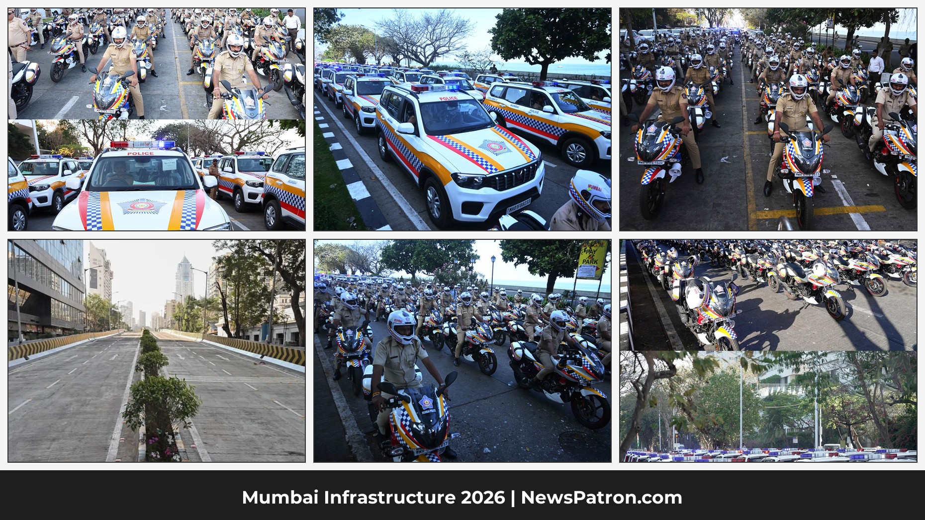
First: Mumbai Police Just Got Its Biggest Fleet Upgrade in a Decade
At Nariman Point, on the morning of 26 February 2026, Maharashtra CM Devendra Fadnavis stood before a line of vehicles that stretched further than most police stations’ entire current fleets — and flagged them all off.
Total: 1,290 advanced vehicles.
The breakdown:
- 633 Mahindra Scorpio Neos (four-wheelers)
- 657 Bajaj Pulsar motorcycles
- 90 Mobile One Vans (patrolling command vehicles)
This is the first fleet upgrade of this scale in nearly a decade. For many Mumbai police stations, this is the first major vehicle addition in 10 years.
Every single police station in Mumbai will now receive:
- 4 Bajaj Pulsar motorcycles
- 4 Mahindra Scorpio Neos
- 1 Mobile One Van
What Is Inside These Vehicles — And Why It Matters
These are not just new vehicles with nicer seats. Each one carries a specific technology stack that changes how policing physically operates.
- Mobile Data Terminals (MDTs): Officers in the vehicle can now access FIRs, suspect records, case history, wanted person databases, and digital maps in real time — without radioing a control room or waiting to return to the station. This alone eliminates a significant delay between “receiving a call” and “knowing the full context before arriving.”
- GPS and Vehicle Tracking Systems: Centralised dispatch can now see exactly where every patrol vehicle is at any given moment. When a distress call comes in, the nearest vehicle is dispatched — not “available vehicle”, not “next shift vehicle”, but the nearest one.
- Mobile One Van: An advanced communication system with GPS tracking, CCTV, wireless facilities, and direct control room contact — essentially a mobile police command post. This is the kind of vehicle that serves as a scene anchor when an emergency unfolds, coordinating officers on the ground.
Joint Commissioner of Police S. Jayakumar stated clearly: “All these vehicles have a mobile data terminal, a vehicle tracking system, and a GPS. With these additions, the response time will also be reduced.”
The 5.30 Minutes — What It Means, and What Comes Next
Currently, Mumbai Police’s average emergency response time is 5 minutes 30 seconds — cited by JCP Jayakumar as the baseline for improvement.
Let us understand what 5.30 minutes actually means in practice:
Recommended Product
Amazon India – Shop Today's Best Offers
🛒 View on Amazon →As an Amazon Associate, we earn from qualifying purchases. Price and availability may vary.
- You call 100. The call is logged. Dispatch identifies a unit. The unit responds. Time to arrival: 5 minutes 30 seconds on average.
- In a fire: the difference between a contained car fire and a burning building.
- In a medical emergency: well within the golden minute window for many critical interventions.
- In a vehicle theft or home break-in: the difference between an in-progress catch and a filed FIR after the fact.
Mumbai Police did not announce a specific new target in seconds. But with GPS-optimised dispatch, the mathematics is simple:
- GPS dispatch eliminates misdirected patrol assignments
- MDTs eliminate the “return to station to access records” detour
- Per-station dedicated fleet eliminates dependency on shared vehicles
Cities that have implemented GPS-only dispatch systems in India (Delhi, Bengaluru pilot zones) have shown 15–30% reduction in average response times within the first six months.
The Bajaj Pulsar brings something else: lane penetration. Mumbai’s traffic makes four-wheelers slow. A motorcycle unit dispatched via GPS can reach a congested area in South Mumbai, Dharavi, Kurla, or Andheri far faster than any SUV — especially at peak hours or during monsoon flooding.
Part Two: After Two Years, the Road Is Back.
Here is something most people do not fully appreciate unless they live or commute through South Mumbai: a critical east-west road link near Mumbai Central railway station was simply absent for nearly two years.
A 130-year-old British-era bridge near Mumbai Central station — officially the Bellasis Road bridge — was declared structurally unsafe. It was dismantled. And then, for close to 24 months, the road corridor it served ceased to exist in any usable form.
Commuters going from Tardeo to Nagpada to Mumbai Central station — or in the reverse direction — had to navigate a maze of detours through roads not built to absorb the additional load. Those roads are Jehangir Boman Behram Marg, Dr. Dadasaheb Bhadkamkar Marg, Pathe Bapurao Marg, and approach roads near Mahalaxmi station bridge. Every vehicle that could not use the Bellasis bridge spilled onto one of these routes. For two years.
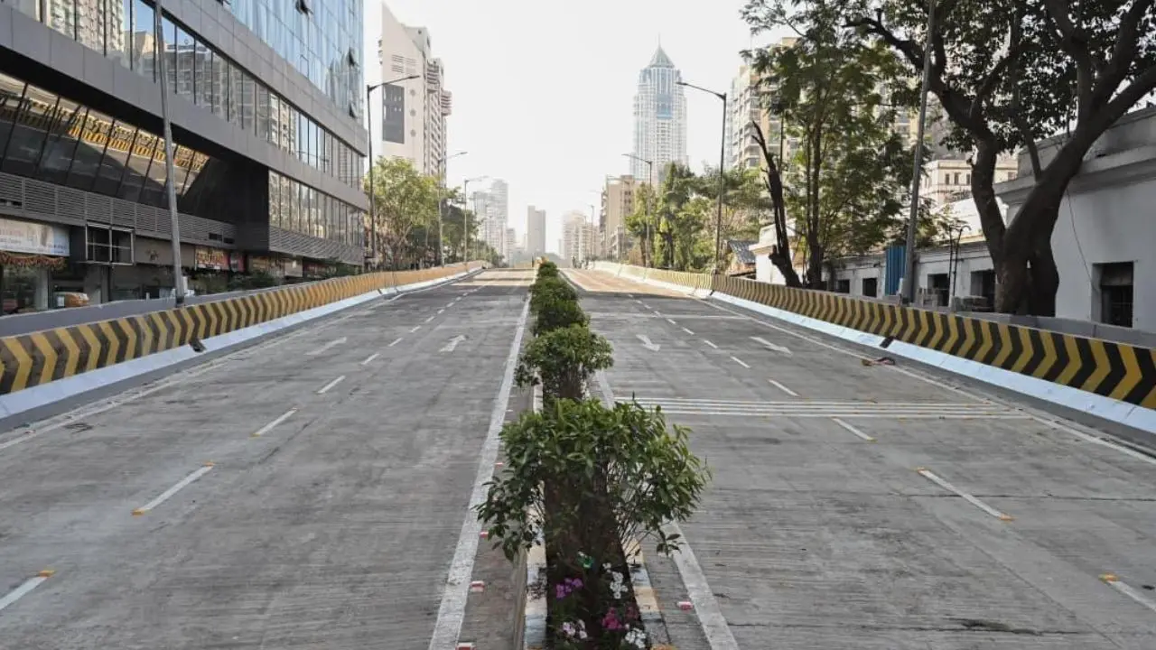
The Flyover: Exactly What Was Built
The structure that opened on 26 February 2026 is the Punyashlok Ahilyadevi Holkar Flyover — named by CM Fadnavis after the legendary Maratha queen Ahilyadevi Holkar, known for her public works legacy.
Technical specifications:
- Total length: 333 metres
- Eastern arm: 138.39 metres
- Western arm: 157.39 metres
- Within railway limits: 36.90 metres
- Carriageway: 7 metres wide, bi-directional
- Footpaths: Wide pedestrian paths on both sides
- Construction period: 15 months and 6 days — led by BMC Additional Commissioner (Projects) Abhijeet Bangar
- Completion status: 4 months ahead of schedule as per original tender conditions
- Safety certificates, load tests, and Railway NOC: all obtained before opening
The inauguration was done virtually by CM Fadnavis via videoconference, with Deputy CMs Eknath Shinde and Sunetra Pawar present, along with Mumbai Mayor Ritu Tawde, BMC Commissioner Bhushan Gagrani, and multiple local MPs and MLAs.
How BMC Built This in 15 Months — When Mumbai Infrastructure Rarely Moves This Fast
The construction of the Punyashlok Ahilyadevi Holkar Flyover faced every obstacle Mumbai infrastructure projects routinely face: relocation of underground utilities, moving residential structures in the alignment zone, removal of boundary walls, multiple court cases, coordinating with the Railway Department, and working with Ward Offices and Mumbai Traffic Police simultaneously.
BMC engineers completed girder bracing, deck sheet construction, slab casting, and approach roads on both sides. All within 15 months. The project was ready four months before the contractual deadline.
This is not a small thing. Mumbai’s infrastructure history is littered with projects that take five, seven, ten years past deadline. A 15-month delivery on a structurally complex flyover over a railway zone — with load tests passed and all NOCs in hand — is worth acknowledging.
Traffic Impact: What Changes From Today
For commuters, the practical benefit is immediate:
- East-west connectivity in South Mumbai is restored. The corridor from Tardeo through Nagpada to Mumbai Central station is now available again, this time on a modern, safe, bi-directional structure.
- Peak-hour relief: Jehangir Boman Behram Marg and Dr. Dadasaheb Bhadkamkar Marg should begin to decompress within days as commuters re-route.
- Time savings: Estimated at 5–10 minutes locally for the tens of thousands who use this junction daily.
- Pedestrian safety: Wide footpaths on both sides give pedestrians a dedicated, elevated, signal-free path.
- Emergency vehicles: Ambulances and the newly deployed Mumbai Police fleet gain a clean elevated route through a congested corridor.
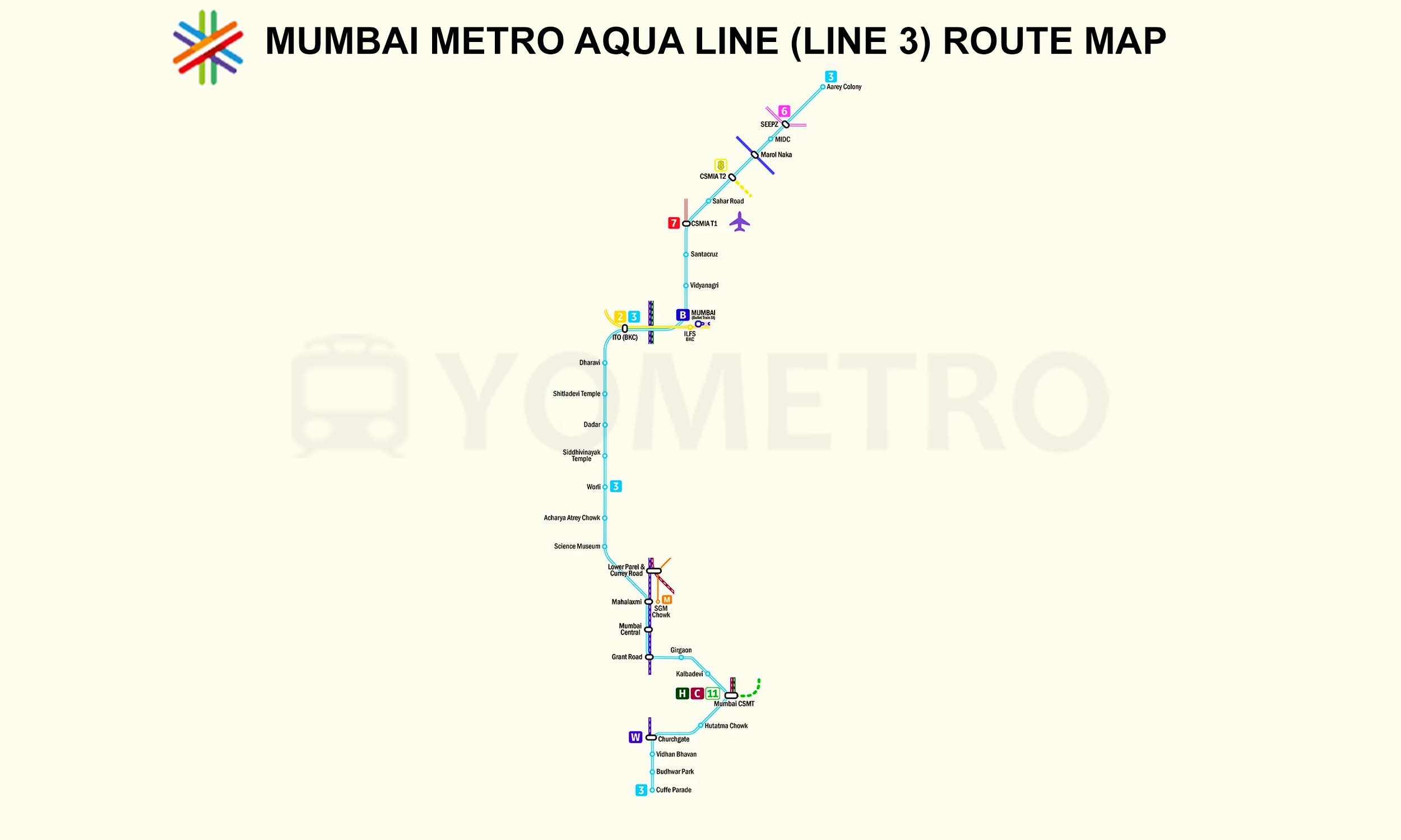
The Third Upgrade You May Have Missed: Mumbai Metro Line 3 is Fully Operational
The Tardeo flyover and the Mumbai Police fleet upgrade did not happen in a vacuum. They land in a city that has, over the last 18 months, added several major infrastructure layers that together create a meaningfully different mobility map for Mumbai.
Mumbai Metro Line 3 (Aqua Line) is now fully operational end-to-end — 33.5 km, 27 stations, from Aarey JVLR to Cuffe Parade, all underground.
What Metro Line 3 means alongside the Tardeo flyover, specifically:
- Line 3 runs underground through South Mumbai with stations near Grant Road, Mumbai Central, Mahalaxmi, Girgaon — the exact zones affected by the old Bellasis bridge closure.
- Commuters in this corridor now have a three-layer option: the new flyover (surface, fast for short distances), the Metro (underground, signal-free), and the suburban rail (via Mumbai Central station itself).
- For the first time in two years, someone coming from the western suburbs into South Mumbai has multiple options that do not all funnel into the same congested ground-level roads.
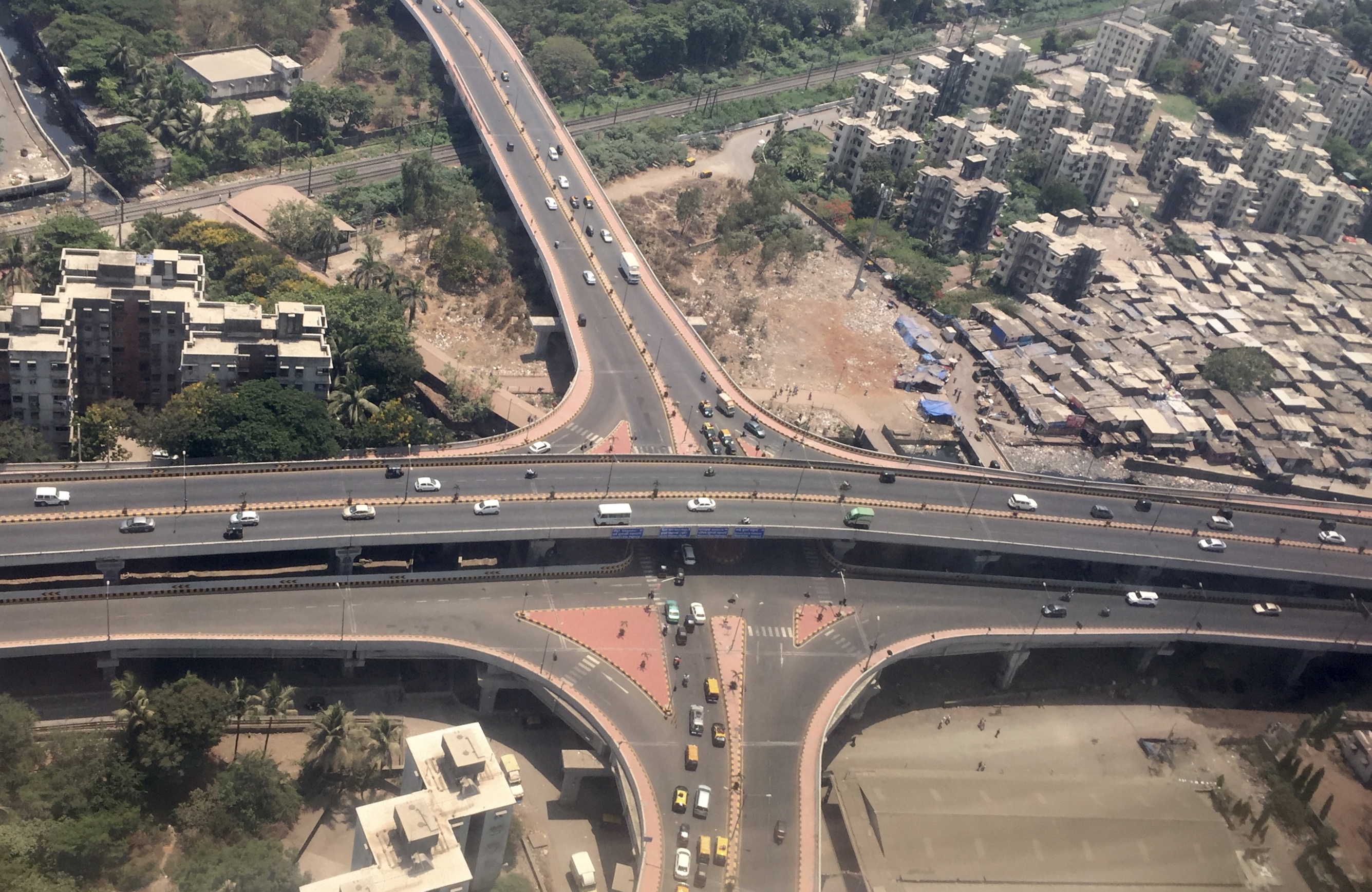
The SCLR Extension: Mumbai’s Engineering Showpiece
The Santacruz–Chembur Link Road (SCLR) Extension opened on 14 August 2025 — six months before the Tardeo flyover, but worth examining alongside it because it solves a completely different piece of Mumbai’s congestion puzzle.
| Parameter | Punyashlok Ahilyadevi Holkar Flyover | SCLR Extension |
|---|---|---|
| Location | South Mumbai (Tardeo ? Nagpada ? Mumbai Central) | Suburban (Santacruz WEH ? Chembur EEH) |
| Length | 333 metres | ~5.4 km (215 m cable-stayed bridge at core) |
| Type | Standard elevated flyover, bi-directional | Signal-free corridor with curved cable-stayed bridge |
| Engineering Feature | Wide footpaths, railway zone crossing | South Asia’s first 90° curved cable-stayed bridge, 25 m height, orthotropic steel deck |
| Completion | 15 months + 6 days (4 months ahead of schedule) | ~9+ years, multiple delays |
| Travel time saving | 5–10 min (local, South Mumbai peak hours) | 15–20 min (east-west suburban, major Vakola relief) |
| Primary problem solved | Restoration of lost connectivity after 2-year closure | Long-missing suburban east-west signal-free corridor |
The SCLR bridge is a 215-metre orthotropic steel deck structure that rises 25 metres above the Western Express Highway, designed around a 90° curve (100-metre radius) — engineering that was considered technically difficult enough that no such structure existed in South Asia before. It was designed specifically to avoid Mumbai Metro Line 3’s underground tunnels, meaning three layers of mobility infrastructure — SCLR above, Metro below, and surface roads alongside — now coexist in the same corridor.
What This All Adds Up To For Everyday Mumbai
When you step back and see all three pieces together — the fleet, the flyover, and the SCLR/Metro combination — you see something that Mumbai residents have been waiting for for a long time: civic infrastructure actually being delivered in converging sequence.
| What Changed | When | Direct Benefit |
|---|---|---|
| Mumbai Metro Line 3 fully operational | October 2025 | 27-station, 33.5 km underground South Mumbai–suburbs corridor |
| SCLR Extension opened | 14 August 2025 | 15–20 min saving on east-west suburban trips; Vakola decongested |
| 1,290 Police vehicles | 26 February 2026 | Faster emergency response, better patrol coverage, first upgrade in 10 years |
| Punyashlok Ahilyadevi Holkar Flyover | 26 February 2026 | East-west South Mumbai connectivity restored after 2 years |
None of this means Mumbai’s infrastructure problems are solved. The city’s housing density, road-to-vehicle ratio, and parking deficit remain what they are. But for the first time in several years, the direction of travel is visible and measurable — not promised, actually built.
This post is based on official statements from the Maharashtra CM’s office, BMC, MMRDA, and Mumbai Police, cross-verified against reporting by Mid-Day, Times of India, Hindustan Times, CNBC TV18, Free Press Journal, and India Today. All specifications, timelines, and figures are drawn from official press releases or verified published reports. Image credits as captioned.
